News and announcements
Greens Lake will be temporarily closed to public access for grounds maintenance
Thursday 17 September 2026
The blanket five-knot restriction has now been lifted at Greens Lake as the lake level is higher than the 99.231mAHD 5 knot trigger point.
About Greens Lake
Greens Lake is on Taungurung Country and forms part of the Eastern Kulin Nation. The lake is part of the Corop Lakes wetland complex and is often used during summer for recreational activities.
Following modifications to enable its use as an irrigation water storage in the 1960s, Greens Lake consistently held large volumes of water and became a popular location for water-based recreation.
Operations
Greens Lake is no longer used as irrigation water supply or storage and as a result is returning to its natural watering regime. The return to a natural watering regime will mean that visitors can expect to see increased flora and fauna including small-bodied fish and many species of water birds, such as the Brolga. GMW is working with stakeholders, including the Goulburn Broken CMA and Taungurung Land and Waters Council, to identify the ecological and cultural objectives at the site. The removal of five pumps that transfer water out of Greens Lake, undertaken as part of the Connections Project, save close to $200,000 in ongoing costs each year. Over ten years, that’s $2 million that would have to be funded by our customers.
The pipe connecting the lake to the irrigation delivery network will remain. In early 2019 consultation was undertaken with the community and local government regarding changes to Greens Lake, feedback received led to building additional amenities around the lake, including the shower and toilet block, bollards and barbecue area.
GMW's core role is to harvest, store and deliver water for its customers and entitlement holders who own water. GMW doesn’t increase storage levels for recreational needs unless requested by a water entitlement holder.
For further information on storage levels, head to our storage levels webpage.
Location
Greens Lake is 6 kilometres north-east of the township of Corop in northern Victoria.
Boating at Greens Lake
Boating rules at Greens Lake change depending on the water level. Check the current water level above and select the relevant section below for the rules that apply.
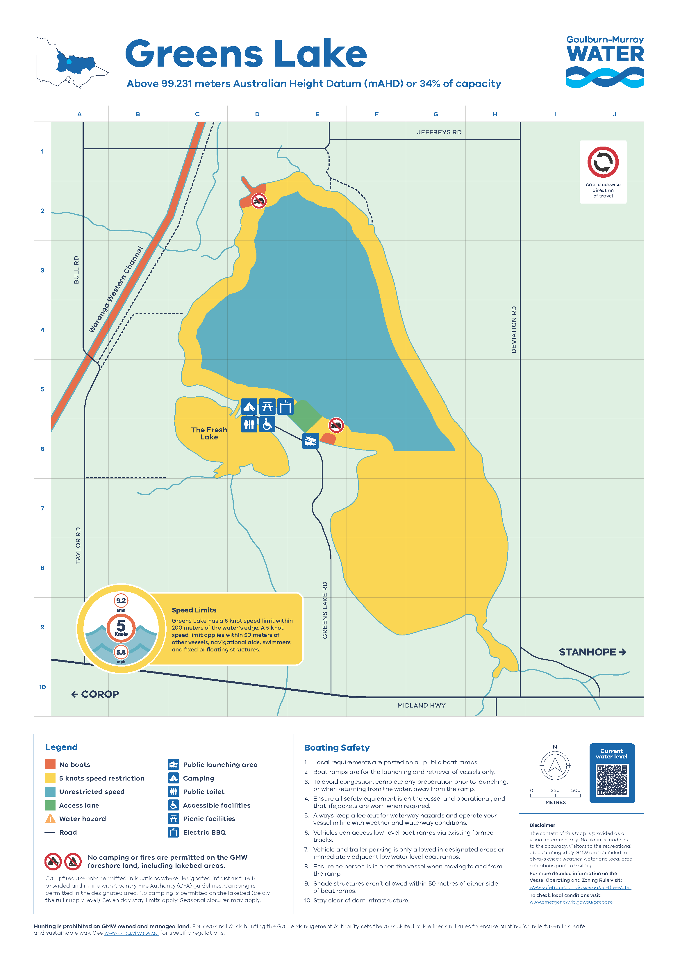
When the lake is 99.231 m AHD or above, the blanket 5-knot speed limit does not apply.
5-knot areas
A 5-knot speed limit applies:
- around the edge of the lake
- south of the marked line of buoys.
No-boating areas
Boating is not permitted:
- In a vessel prohibited zone south of the public boat ramp
- within the designated area around the pump house at the northern end of the lake.
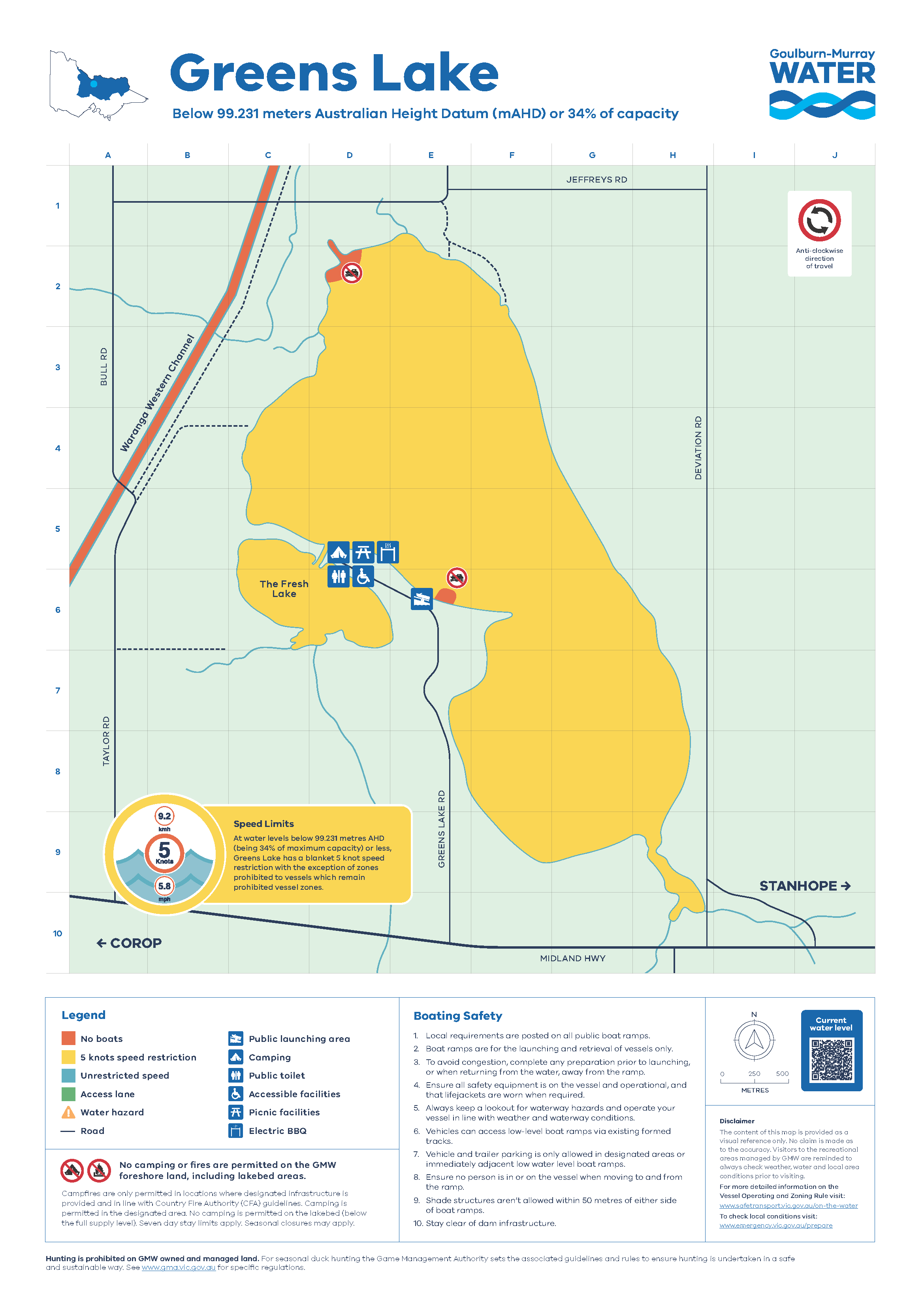
When the lake is below 99.231 m AHD, a 5-knot speed limit applies across the lake.
No-boating areas
Boating is not permitted:
- In a vessel prohibited zone south of the public boat ramp
- within the designated area around the pump house at the northern end of the lake.
Boating map
See the map below for the 5-knot and no-boating areas
Camping at Greens Lake
Camping is permitted above the full supply level on the western foreshore of Greens Lake (see signage onsite). It is free of charge for no more than seven consecutive days .
Campers are reminded Greens Lake operates under a Carry In Carry Out rubbish policy so please keep your campsite tidy and take your rubbish with you.
More information on Greens Lake
Due to improvements and upgrades to the irrigation delivery network Greens Lake is no longer required for storage.
In early 2019 consultation was undertaken with the community and local government regarding changes to Greens Lake. The consultation led to building additional amenities around the lake, such as the new shower and toilet block, bollards and barbecue area.
The future plan for Greens Lake is to return to a natural watering regime and visitors can expect to see increased flora and fauna when the lake returns to a natural watering regime. This includes increased vegetation and habitat complexity, meaning increased breeding and feeding for a diverse range of waterbirds.
The removal of five pumps that transfer water out of Greens Lake, undertaken as part of the Connections Project, save close to $200,000 in ongoing annual costs. Over ten years, that’s $2 million that would have to be funded by our customers. The pipe connecting the lake to the irrigation delivery network will remain.
GMW doesn’t increase storage levels for recreational needs unless requested by a water entitlement holder. Its core role is to harvest, store and deliver water for its customers and entitlement holders who own water.
GMW is working with stakeholders, including the Goulburn Broken CMA and Taungurung Land and Waters Council, to identify the ecological and cultural objectives at the site.
For further information on storage levels, head to our storage levels webpage.