Click on each of the links below to read information about our catchments. You will find a lot of useful information about land and stream networks, rainfall and surface hydrology, groundwater, water use, surface water quality and water storages that relate to the catchments.
Dartmouth Dam
The Upper Murray River Basin forms the catchment of Hume Reservoir and covers an area of 15,280 km 2 in New South Wales and Victoria. The Murray River forms the north and east sides of the Victorian part of the Basin. The southern boundary extends across the Dividing Range from Forest Hill to Mt Hotham, and the western boundary runs north between the Kiewa and Mitta Mitta Rivers to Lake Hume.
The Victorian portion of the Upper Murray River Basin covers an area of 10,15...
The Kiewa River Basin is the third smallest of Victoria's basins and occupies a narrow strip in the north-east of the state.
It is approximately 100 km long and typically only 20 km wide, extending from the Bogong High Plains northward to the Murray River.
The rivers flows are highly utilised in diversions from the Murray River downstream of Albury.
Kiewa River
The topography is hilly to mountainous and consists of alpine peaks and plateaux and highly dissected valleys. Victoria's highest peak...
The Ovens River Basin is located in north-east Victoria and covers an area of 7,985 km 2. The area extends from the Murray River in the north, to the Great Dividing Range in the south and is bordered by the Broken River Basin in the west and the Kiewa River Basin in the east. The topography of the Basin is diverse ranging from riverine plains near the Murray River and broad alluvial valleys around Myrtleford, to rugged alpine peaks and plateaux around the Great Dividing Range. Mt Buffalo, a larg...
The Broken River is one of the tributaries of the Goulburn River in north-eastern Victoria. The River Basin named after it also includes the catchment of Broken Creek which diverges from the Broken River and flows in a north-westerly direction to the Murray River. The Basin covers 772,386 hectares.
Land and stream network
Lake Nillahcootie
The Basin contains two connected stream networks, that of the Broken River in the southern half and the Broken Creek in the north.
In the far sou...
The Goulburn River Basin covers 1,619,158 hectares in central Victoria and extends from the Great Dividing Range near Woods Point, to the Murray River in the north-west near Echuca.
Lake Eildon
Land and stream network
Terrain in the Goulburn River Basin varies from the high ranges to the Murray Plain. The southern boundary of the Goulburn catchment runs along the Hume Range and the Great Dividing Range, then swings northward to Mount Buller at 1,804 m in the south-east.
Lake Eildon ...
The Campaspe River Basin occupies 417,914 hectares of north central Victoria. It extends 150km south from the Murray River to the Great Dividing Range and is 45km wide at the widest point.
Lake Eppalock
Land and stream network
Agriculture in the Basin is characterised by the flat alluvial plains of the Murray Valley, the elevation of which rarely exceeds 200m above sea level. These plains meet the northern slopes of the Great Dividing Range which make up the remainder of the Basin wh...
The Loddon River Basin extends approximately 300km from the Great Dividing Range between Daylesford and Creswick, to Swan Hill on the Murray River. Varying in width from 15km at Swan Hill to 100km along the Divide, the Basin covers 1,531,998 hectares.
Cairn Curran Tower
Land and stream network
Mount Alexander is the highest point within the Basin, peaking at 741m in the Great Dividing Range. The foothills of the range extend over much of the southern section of the Basin, where...
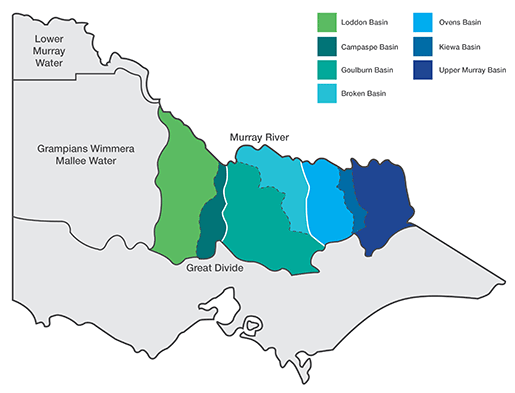
Goulburn-Murray Water is responsible for the management of seven river basins and their associated water supply systems, north of the Great Divide covering approximately 68,000 square kilometres.
Each river basin is composed of the catchment for one or more major rivers and their tributaries. The catchment of a water body (river, stream, dam, etc) is the area of natural and man-made landscape from which water flows into the water body.