The Goulburn River Basin covers 1,619,158 hectares in central Victoria and extends from the Great Dividing Range near Woods Point, to the Murray River in the north-west near Echuca.
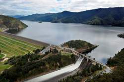
 Lake Eildon
Land and stream network
Terrain in the Goulburn River Basin varies from the high ranges to the Murray Plain. The southern boundary of the Goulburn catchment runs along the Hume Range and the Great Dividing Range, then swings northward to Mount Buller at 1,804 m in the south-east.
Lake Eildon lies in the south-east of the Basin and collects flows from the Upper Goulburn, Jamieson, Big, Howqua and Delatite Rivers as well as Ford and Merton Creeks. From Eildon, the Goulburn River flows in a westerly direction, through a broad agricultural valley bordered by foothills. The major tributaries along this reach are the Rubicon, Acheron and Yea Rivers.
Near Seymour the river swings to the north and continues through the Goulburn Weir near Nagambie. After taking in the waters of the streams draining the northern face of the Strathbogie Ranges, the Goulburn River flows past Shepparton to finally join the Murray River just upstream from Echuca. The northern half of the Basin is relatively flat and much of the land has been cleared. Past Shepparton the valley widens to merge with the Murray Plains.
Rainfall and surface hydrology
Climate varies substantially from the headwaters of the Goulburn River to its confluence with the Murray River. The high country in the south-east experiences cool winters with persistent snow. Rainfall is highest at Mt Buller and decreases in a north-westerly direction. Mansfield, Yea and Alexandra lie in rain shadows and generally experience a lower annual rainfall. Rainfall continues to decrease northward and in the far north of the Basin precipitation is only a third of annual evaporation in that region.
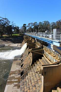
Streamflow along the Goulburn River has been modified by two major features, Lake Eildon and the Goulburn Weir. Under natural conditions the average annual flow of the Goulburn River increased by approximately 44 per cent between Eildon and Nagambie. The three months of greatest flow were July to September, accounting for 52 per cent of the annual total, and the three months of least flow were January to March, accounting for 5 per cent. Operation of the Eildon Reservoir has reduced the July to September flows passing Eildon to 33 per cent of the annual total, allowing an increase of the January to March flows of 23 per cent of the annual total. The Goulburn Weir near Nagambie and associated diversion channels to the east and west of the river, serving the Goulburn-Murray Irrigation District, have reduced the average annual down river flow to less than half the pre-regulated flow.
 Goulburn Weir
Groundwater
The shallow aquifer systems of the Goulburn River Basin occur in three main hydrogeological situations. The Shepparton Formation aquifer lies throughout the northern sections of the Basin and is composed of shoestring sands, amongst silt and clay. The quality of groundwater contained in this aquifer is generally brackish. The remaining central and southern portion of the Basin comprises outcropping basement rocks overlain, in the valleys within the highlands, by Quaternary alluvial sand and gravel. Groundwater in these two units is generally of good quality.
A deep aquifer system, in the form of buried sand sheet known as the Calivil/Renmark Aquifer, is found in the far north of the basin at a depth of more than 80m underlying the Shepparton Formation.
The total groundwater resource is estimated to be 53,800 ML per year. More than 70 percent of the divertible resource is of brackish quality, the remainder being marginal. The minor resource is generally of fresh to brackish quality. Bores are concentrated in the north-east of the Basin where water quality varies from brackish to saline. Less saline waters are drawn from those bores sunk in the western section of the Basin. The water quality generally declines from east to west.
Land use
Agriculture in the Basin is diverse, ranging from hardwood timber production in the south-east to dairying and fruit production in the north. Tongala, Tatura and Shepparton are noted dairying centres in the Murray Valley and the Shepparton area is also well known for its pome and stone fruit production. The Lake Eildon environs produce sheep for wool, and beef and dairy cattle. Further along the Goulburn Valley, sheep and cropping are important in dryland and irrigated areas. Severe dryland salting is experienced in the area west of Seymour.
Lake Eildon is located on the Goulburn River in its upper catchment, immediately below the junction with the Delatite River.
Goulburn Weir is located on the Goulburn River, approximately 8 km north of Nagambie.
Waranga Basin is located between the Goulburn and Campaspe River basins, approximately 8 km north-east of Rushworth.