Background
Lake Eppalock is currently close to full capacity. This can largely be attributed to the higher than average rainfall stemming from three consecutive La Niña events and a negative Indian Ocean Dipole.
2022 was only the third time since records began in 1900 that a La Niña weather pattern had occurred in three consecutive years.
Lake Eppalock’s current state
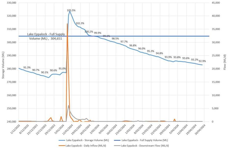
Lake Eppalock is currently 92.9 per cent as of 11 am, 24 April 2024.

A graph depicting how storage levels changed since December 2023. The dark blue line shows the full supply level at Lake Eppalock, with the light blue one showing the storage level. The orange line shows the inflows into Lake Eppalock, with the grey line showing the outflows.
Updates to daily release plans can be found under the Lake Eildon drop down on the Managing Water Storages webpage
How the storage level is managed at Lake Eppalock
The spillway at Lake Eppalock is a fixed crest spillway, which means GMW is unable to release more water than the capacity of the outlet valve, which is 1,600 ML/d.
Releases are made through the outlet valve to meet water orders from entitlement holders, and to pre-release in advance of predicted rainfall that would result in the dam spilling.
During spill events, downstream flows are governed by how high the storage level exceeds the full supply level.
While GMW storages are not specifically for flood mitigation, Lake Eppalock does mitigate downstream flows by storing water above the full supply level and water passing over the spillway.
GMW’s responsibilities
The requirements for GMW to manage its storages are set out in the Victorian Water Act.
The Act advises that the primary role of GMW storages is to harvest and store customers' water entitlements. However, GMW can provide flood mitigation benefits at some storages, including Lake Eppalock, where possible.
If downstream flows approach flood thresholds. GMW will work closely with the State Emergency Services (SES) and Bureau of Meteorology to ensure timely dissemination of information to the community.
The SES is the lead agency responsible for issuing flood advice should it occur.
Lake Eppalock Assessment
The Department of Energy, Environment and Climate Action is leading an assessment into the infrastructure and operating arrangements at Lake Eppalock.
More information on the assessment can be found on DEECA's website.
Webinar: Managing Lake Eppalock
Goulburn-Murray Water held a webinar on Thursday 6 July 2023 to share information about how Lake Eppalock is managed and the role the storage plays during times of flood.
View the recording, presentation and Q&A on our Webinar: Managing Lake Eppalock webpage.
More Information
For more information visit www.gmwater.com.au/managing-storages or phone GMW on 1800 013 357.