Closure of the Yarrawonga Weir Bridge to public vehicle traffic
The Yarrawonga Weir Bridge is permanently closed to public vehicle traffic.
The Murray–Darling Basin Authority (MDBA), Transport for NSW and Regional Roads Victoria have confirmed the Yarrawonga Weir is closed to traffic to ensure the ongoing safety and structural integrity of weir.
About Yarrawonga Weir
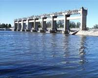 Yarrawonga Weir Upstream
Goulburn-Murray Water operates Yarrawonga Weir on behalf of the MDBA , opens in a new window . It is the largest of the 16 weirs managed by the MDBA.
Location
Yarrawonga Weir is located on the Murray River near the towns of Yarrawonga in Victoria and Mulwala in NSW. The Weir is approximately 230 km downstream of Lake Hume and 1,992 km from the Murray mouth.
History
Construction of the weir and its offtakes began early in 1935 and was completed in 1939. The water impounded by the Yarrawonga Weir forms Lake Mulwala, which has a capacity of 117,500 ML.
A hydro-electric generation facility at Yarrawonga Weir was commissioned in June 1994. The facility has a maximum capacity of about 9.6 MW.
Operations
Yarrawonga Weir raises the water level of the River Murray to allow diversions of water under gravity. An average of 1,900 GL or 17% of the river's annual flow is diverted annually to the Yarrawonga Main Channel and the Mulwala Canal.
The Yarrawonga Main Channel services the Murray Valley Irrigation Area of Victoria, which extends from Yarrawonga to Barmah and south to the Broken and Nine Mile Creek systems. The channel has a discharge capacity of 3,100 ML/d and distributes water to an area of 128,000 ha via a network of six main channels and 261 spur channels.
The Mulwala Canal is a much larger structure and has an offtake capacity of 10,000 ML/d. Water diverted through the Mulwala Canal supplies the Berriquin, Denimein, Deniboota and Wakool irrigation districts in southern New South Wales. The total annual water allocation to these districts exceeds 1,000,000 ML over an area of 700,000 ha.
A unique feature at Yarrawonga Weir is the fish lift located adjacent to the power station. Constructed in 1994, the lift provided the first opportunity in 60 years for fish to travel upstream of the weir.
Jetties
For more information on jetties please visit our Foreshore Occupation Licences page.
Further Information
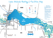
Lake Mulwala Boating & Facilities Map