Tullaroop Reservoir

Water Storage Levels

Last Updated 18/03/2024
Current Volume 65712
% of Capacity 90.08
Capacity (ML) 72950
96.8%
95.9%
95.5%
92.6%
90.1%
Nov Dec Jan Feb Mar

Recreational Facilities

No Swimming Large Grassed Area Car Parking Boat Ramp Fishing BBQ - Woodfired Toilets

Facts & Figures

Name Tullaroop Reservoir
Stream Tullaroop Creek
Year of Completion 1959
Construction Earth and Rockfill
Full Supply Level 222.8 m AHD
Capacity 72,950 ML
Area Submerged 742 ha
Main Embankment Length 427 m
Main Embankment Height 42 m
Hydro-electric Generation nil MW
Tullaroop Reservoir
Tullaroop Reservoir

About Tullaroop Reservoir

There is currently a blue-green algae warning for Tullaroop Reservoir . Click here for more information.

Location

Tullaroop Reservoir dams the Tullaroop Creek, a tributary of the Loddon River. The storage embankment is situated about 7 km south-east of Carisbrook.

History

Tullaroop Reservoir was built between 1958 and 1959. The construction involved substantial excavation, including the removal of 300,000 cubic yards of material from the bed of Tullaroop Creek.

Operations

Tullaroop Reservoir stores water for supplies to irrigated properties along Tullaroop Creek and the Loddon River.

Supplementation of the western sector of the Goulburn water supply system using Loddon River resources such as that held in Tullaroop Reservoir occurs when water resources are abundant.

The reservoir also provides water for Maryborough.


Recreation and Tourism at Tullaroop Reservoir

Facilities Available

No Swimming No Swimming
Large Grassed Area Large Grassed Area
Car Parking Car Parking
Boat Ramp Boat Ramp
Fishing Fishing
BBQ - Woodfired BBQ - Woodfired
Toilets Toilets
Please observe all signs and directions around our storages for information on recreational activities. Refer to the Land and On-Water Management Plan (if provided above) for detailed information on the facilities available.

Further Information

Picnic, boat launching and toilet facilities are accessible to the public. Boating is restricted to manually operated craft (canoes and kayaks) and vessels powered by electric motors and there is a maximum allowable speed of 5 knots. The operation of petrol engines is strictly prohibited. Swimming and camping are not permitted at this reservoir.

When the Reservoir is above 222.800 Australian Height Datum (water is flowing over the Spillway), this is a safety trigger level where all boating on the Reservoir is prohibited.

Boat users are asked to be aware of the dangers associated with low water levels and abide to all safety restrictions.         

 Lake Levels 222.800 Australian Height Datum and below - click to enlarge
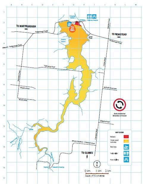
 Tullaroop Lake Levels 22.800 Australian Heigh Datum and below, link opens in a new window

Lake Levels 222.800 Australian Height Datum and above - click to enlarge
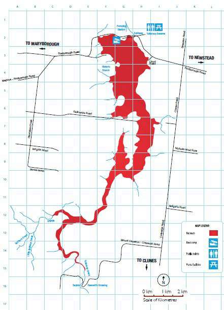
 

Tullaroop Reservoir, link opens in a new window