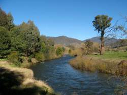
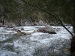
The Kiewa River Basin is the third smallest of Victoria's basins and occupies a narrow strip in the north-east of the state.
It is approximately 100 km long and typically only 20 km wide, extending from the Bogong High Plains northward to the Murray River.
The rivers flows are highly utilised in diversions from the Murray River downstream of Albury.
 Kiewa River
The topography is hilly to mountainous and consists of alpine peaks and plateaux and highly dissected valleys. Victoria's highest peak, Mt Bogong, and the nearby Bogong High Plains are located in the southern headwaters of the basin. From the headwaters, the east and west branches of the Kiewa Rivers and Mountain Creek flow through alpine terrain and gorge-like valleys to meet in the vicinity of Mt Beauty.
The next major tributary is Running Creek which joins from the west in the central portion of the Basin. The Stanley Plateau and Mt Big Ben to the west provide water to the numerous tributaries of Yackandandah Creek. Yackandandah Creek itself is the largest tributary of the Kiewa River and it joins from the south-west just downstream from the township of Kiewa. Middle Creek is the northernmost tributary of the Kiewa River and is separated from the Yackandandah Creek by the Baranduda Range. The Kiewa River joins the Murray River just east of Wodonga, below Lake Hume.
Rainfall and Surface Hydrology
Within the Kiewa River Basin most of the precipitation occurs as rain, while in winter, snow falls above 1,400 m. Average annual rainfall gradually increases from the north of the catchment to the south with increasing elevation. Within the Basin only 23 percent of the land has an elevation greater than 900 m, however, this area produces as much as 52 percent of the Basin yield.
The flow regime of the Kiewa River displays a marked seasonal variation, with the three months August to October accounting for about 50 percent of annual stream flow, and the three months January to March for only about 7 percent.
The storages operated for hydro electric power generation in the high country, such as the Rocky Valley Storage and the Mt Beauty Pondage, modify, to a small extent, the natural flow regime of the Kiewa system.
 Kiewa River Mount Beauty
The shallow aquifer system of the Kiewa River Basin has two principal provinces;
- the minor fractured rock aquifers of sedimentary rocks, granite and basalt, and
- the important aquifer of alluvium of the Kiewa River system.
Groundwater quality is generally excellent throughout the Basin. Divertible groundwater resources are fresh. Minor resources are of marginal to brackish quality.
In the Kiewa River Basin, 13,160 ML of water are used in an average year.Urban and Industrial use accounts for about half the total use.All of the water is supplied from surface resources within the Basin except for a very small portion that is extracted from the divertible groundwater resource for commercial use. Three-quarters of the water supplied to this sector is for domestic use. Irrigation use accounts for the majority of other half of the total volume used. There is no reticulation system and all the water is self-extracted by private irrigators from either surface resources or from the Murray River, with a small amount drawn from groundwater. More than half the water used for irrigation is for pasture and the remainder is for crops and horticulture. The small amount of water remaining is used for rural uses.
Kiewa Water Storages
The major storage in the basin is the Rocky Valley Reservoir, with a capacity of 28,400 ML.It is located on the Bogong High Plains at an altitude of 1,700 m above sea level and is the main storage for the Kiewa Hydroelectric Scheme. The Scheme produces 300 gigawatt hours annually on average, and is an important producer of peak load power. Other smaller storages associated with hydro-power generation include the Pretty Valley Pondage (Bogong High Plains), Lake Guy (Bogong Village) and the Mt Beauty Pondage. From the last station near Mt Beauty water is discharged to an off-river pondage for regulated release back into the river.