The Broken River is one of the tributaries of the Goulburn River in north-eastern Victoria. The River Basin named after it also includes the catchment of Broken Creek which diverges from the Broken River and flows in a north-westerly direction to the Murray River. The Basin covers 772,386 hectares.
Land and stream network
 Lake Nillahcootie
The Basin contains two connected stream networks, that of the Broken River in the southern half and the Broken Creek in the north.
In the far south of the Basin, the Broken River flows westward from its sources in the deeply dissected Tolmie Highlands, then swings to the north near Mount Strathbogie before entering Lake Nillahcootie. The Broken River continues north through undulating farmland towards Benalla and takes in the waters of Moonee, Blind, Holland and Ryans Creeks. North of Benalla the Broken River swings to the west and overflows to the effluent Broken Creek. It then continues on a westward course across the riverine plain and joins the Goulburn River just south of Shepparton.
Broken Creek flows north through a swampy area, then swings to the west and takes in the waters of Boosey Creek at Katamatite. It meanders westward past Nathalia and joins the Murray River upstream from Barmah.
Rainfall and surface hydrology
The average annual rainfall is highest at Mt Strathbogie and in the Tolmie Highlands in the south of the Basin. Above approximately 750m, light snowfalls are fairly regular in winter. From the higher plateaux, mean annual rainfall decreases to about 55 per cent of that at Mount Strathbogie on the Benalla Plain. Rainfall generally continues to decrease northward. Across the far northern section, rainfall generally increases from the west to the east. Reliability of rainfall varies notably over the Basin, being greatest in the elevated areas of high water production, such as on the Tolmie Highlands, and lowest on the plains. Generally in the plains region, summer is hot and winter mild. Streamflow within the Broken River Basin is extremely variable over the seasons of the year, and between years. The three months July to September account for over half of average annual flow.

Lake Mokoan
Groundwater
For the southern portion of the Basin, in the highlands, shallow aquifers occur in the Palaeozoic basement rocks of folded sediments, metamorphic and granite, whereas in the northern portion of the Basin, in the riverine plain, the shallow aquifer is a complex network of shoestring sands of the Shepparton Formation. The deep aquifer system is restricted to the north of the Basin in the buried sand sheet of the Calivil/Renmark Aquifer.
Groundwater quality varies throughout the Basin. Divertible resources lie mostly in the far north and the south of the Basin with these areas containing good quality water. The minor resources in the Basin are generally located in the central region and quality is generally brackish.
Land use
Most of the Basin has been cleared for agriculture which supports grazing in the south, and mixed cereal and livestock farming in the central region. A large part of the northern section of the Basin is within the Goulburn-Murray Irrigation District, with irrigation for fruit growing, dairying and livestock production.
Broken water storages
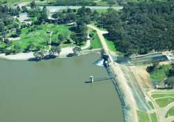
The Broken River has one major storage, Lake Nillahcootie. Water can be released progressively from this storage to supplement flows in the Lower Broken River and via the Lower Goulburn River to the Murray River.
Lake Nillahcootie is situated on the Broken River in north-eastern Victoria, 36km south of Benalla.